Categories
Innovator's Vista

Drones for Last Mile Delivery

Categories
Innovator's Vista

Drones for Last Mile Delivery

Last mile delivery refers to the last step of the delivery process when a parcel starting from the shelf of a warehouse reaches its final destination through a transportation hub. It is a crucial step that determines the holistic perception of brands by the consumers. It is also the most expensive step as it costs 53% of the overall delivery.

These reasons have led the companies to invest significantly on improving the customer experience and work on last mile delivery strategies. A range of technologies like telematics, hybrid fleet systems, delivery robots etc. are being used for the purpose. Drones are also being considered as an important part of modern logistics operations.

Drones or Unmanned Arial Vehicles are increasingly being used to transport medicines, parcels, groceries, food, and other products. They are accurate, environment-friendly, have shorter delivery time, and operate on lower costs than traditional delivery channels. The GPS technology based advanced navigation systems, and ability to operate autonomously make them better suited for delivery in rural and remote areas.

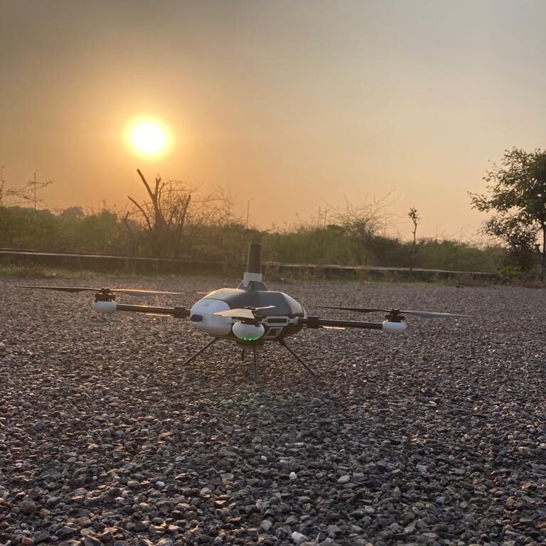
Drones rely on Motors, Propellers, GPS and other onboard sensors like Accelerometer, Gyroscope, Magnetometer, Barometer, Distance Sensor etc for functioning. A Drone can be fixed wing type that has one rigid wing and works like an airplane. These drones cannot stay in one place and glide on a path set. Another type is VTOL i.e. vertical take-off and landing, these drones, as the name suggests, can take off, hover, and land vertically. Drones are also categorised on basis of rotors used as multi-rotor and fixed-rotor drones.

A Gurugram-based startup, TechEagle, started in 2015 at IIT Kanpur, has developed e-VTOL, an electric vertical take-off and landing (e-VTOL) drone. The drone has a range of 100 km, a payload capacity of 3 kgs and can achieve maximum speed of 120 km/hr. Named Vertiplane X3, the company claims it to be the fastest Made-In-India hybrid drone.

Anshu Abhishek, Cofounder, Tech Eagle at Open Innovator Meet

TechEagle was one of the participants at OPEN INNOVATOR MEET where COO & Co-founder, Anshu Abhishek, informed about the accomplishments and plans of his company. The Startup has conducted trials with food delivery companies like Zomato and Swiggy. It has also worked with State Governments of Telangana, Meghalaya and Himachal on delivering medicines and vaccines. The company, recently, has also carried out parcel delivery with India Post in Kutch.

The company also plans creating a network of on-demand drone delivery for healthcare. Drones are being used in various applications like video/photography, inspection, monitoring, and surveying, but in healthcare drones can play very significant role by rapid and targeted delivery of vaccines, medications and supplies. Drones by delivering medical supplies right at the home of the patient can reduce footfall at the hospitals and clinics and hence improve the productivity of medical professionals and emergency responders.

India is witnessing a significant rise in the number of drone start-ups. According to IBEF, since August 2021 drone start-ups in the country has surged by 34.4% to around 350 startups.


Categories
Innovator's Vista

Drones for sectors like Agriculture, Industrial, Environmental, Public and Private agencies

Categories
Innovator's Vista

Drones for sectors like Agriculture, Industrial, Environmental, Public and Private agencies

Unmanned Aerial Vehicles is a class of aircrafts that can fly without the onboard presence of pilots. They can be handled remotely with a controller or tablet (Drones) or operate autonomously. They are equipped with different state of the art technology such as infrared cameras, GPS and laser with remote ground control systems (GSC).

Impact of commercial drone — drones made for specific types of jobs both corporate and consumer applications — on country’s GDP is increasing. It is among the fastest-growing market in the world and according to a Business Today Report India’s UAV market will be worth $1.81 billion (or Rs 13,575 crore) by FY26, while the Drone Federation of India estimates the industry to touch Rs 50,000 crore in the next five years. 

Due to limitations on economic front in surveillance, difficulty in operating in narrow and confined spaces, traveling long distances manually. Unmanned aerial vehicles are finding application in various sectors as payload delivery, traffic monitoring, surveillance and in sectors like Agriculture, Industrial, Environmental, Public and Private agencies.

Aerosys Aviation India, a startup is working on developing drones for various applications. The company is using Design Thinking, creativity, Innovation and Analytical Approach to solve complex problems.

Some of the solutions they provide are:

Land surveying: Survey drones generate high-resolution orthomosaic—large, map-quality image with high detail and resolution made by combining many smaller images— and detailed 3D models of areas where low-quality, outdated or even no data, are available.

Surveillance: UAVs equipped with an RGB camera allow them to provide imagery of different Areas. Drones can cover large areas with minimal time or period of non reachable areas with low risk and cost effectiveness. Surveillance is the observation of a person, crowded areas, infrastructure, behaviour, activities, building etc for the protecting and managing purpose.

Agriculture: Detection of issues like disease, water stress, pest infestation, nutrient deficiencies, and more. The specific filters on multispectral cameras highlight changes in chlorophyll content in plants, which is oftentimes an indicator of disease or stress.

Apart from this the company is also working on providing solutions for Border Security, Forest and Wildlife Monitoring, Infrastructure inspection in Railways, Mining, and Oil and Gas Industry.

One of their better known drones is “Vedansh UAV”, a Micro category class Quadcopter Drone, made exclusively for Surveying & Mapping purpose. It uses a dual battery pack technology for greater endurance during the flight. It is built of Carbon composite material keeping its weight factor in consideration. It has integrated in it for Superior mapping accuracy with indigenous dual-frequency RTK/PPK system (a GPS correction technology).

Overall it can be stated that Drones lead to reduction in field crews and decrease risk with highly detailed data. Increased revenue, investment through additional analysis of value-added products, made possible from high-resolution imagery. Key Customers include Governments, Companies working on Agriculture, Construction, Surveillance,Traffic Management etc.